HMS Hampshire sank on the 5th June 1916 when she struck a mine laid by German U-Boat U75. The wreck is located in approximately 60 meters of water off the west coast of Orkney and sank while en-route to Archangel in Russia. She was transporting Lord Kitchener, Secretary of State for War, to a meeting with Tsar Nicholas II.
Many sailors perished that day and as such the wreck site is considered a war grave and restricted area for shipping and diving. In the run up to the centenary of the loss of the HMS Hampshire permission was given to carry out a condition survey and map the extent of the wreck site.
Sandra Henry continues: "This survey is being undertaken as a mark of re spect and remembrance for those who lost their lives aboard, and all those who lost their lives at sea during the First World War."
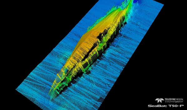
Equipped with a SeaBat T-50-P the wreck site was mapped in great detail. The imagery confirmed previous findings that HMS Hampshire capsized as she sank and lies with an upturned hull on the seabed in approximately 60m of water. The superstructure itself is compressed and the hull is damaged in places throughout the length of the vessel. The data was recorded and processed with Teledyne PDS.
Sandra Henry, University of the Highlands and Islands Archaeology Institute said that "This remote survey has provided many new insights into the sinking and wreck of the HMS Hampshire. Ongoing work will continue to develop our knowledge base, revealing new information as we continue to gather and process data, creating a record of the Hampshire in 2016"
For more information:
Pim Kuus ([email protected])
Sandra Henry ([email protected])
Alistair Coutts ([email protected])

