 Teledyne 3D Mechanical Scanning Sonar to Inspect Bridge Footing Damage and Scour
OVERVIEW
The U.S. currently has the largest road network of any country on earth, with more than 4 million miles of roads and streets. However, according to the 2017 Report Card for Amer-ica’s Infrastructure, nearly two hundred million trips are taken daily across deficient bridg-es. In total, one in 11 of the nation’s bridges are rated as structurally deficient, while the average age of the nation’s bridges is currently 43 years. This poses a major long-term challenge for those tasked with ensuring the safety of these structures.
During routine underwater bridge inspections using divers, the Minnesota Department of Transportation (MnDOT) received a report that corrective maintenance to the Third Avenue Bridge substructure should be programmed due to a scoured area underneath the bridge pier support. The area underneath that support had deteriorated significantly since the last inspection cycle. Scour is a dangerous phenomenon caused by swift moving water that can scoop out holes in the sedimentation and other materials required to maintain safe bridge supports.
MnDOT began this project with the aid of a consultant with underwater repair expertise. The consultant started work, but the early onset of frigid winter temperatures and ice buildup around the area of interest caused the project to stall.
To create a low-risk repair plan, additional information on the substructure condition was required, and the harsh conditions combined with the dangerous location had deterred conventional underwater investigation techniques. MnDOT contacted Teledyne to discuss their sonar scanning capabilities, which would allow for inspections even in these harsh conditions.
Teledyne works extensively with civil engineering dive and inspection teams around the world to help enhance the deliverables to their cus-tomers using both 2D and 3D imaging sonar. The data from these sonars helps prioritize engineering decisions for inspection, repair, and main-tenance, and verifies that work is completed to specifications.
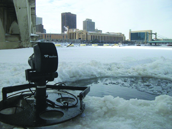
Teledyne’s sonar was placed on the bottom in different locations around the nose of the MnDOT bridge support to image the scoured-out areas. The project was conducted in February 2014, when the water was frozen over, so multiple holes were cut in the ice sheet to deploy the sonar to the scan location. Lowering the instrument to the river bottom gives the sonar a unique perspective on any scour and vertical structure. This low perspective gives the operator the capability to measure the height, width, and depth of the scour. In many instances, the generated point cloud can be used with software to calculate the volume of material removed or missing.
After the area of interest was scanned, the individual scan locations were merged using point cloud processing software to deliver a complete mosaicked image of the area of interest. This data gave the construction and repair contractors the critical information they needed to better understand the condition of the bridge. This, in turn, enabled them to make a more accurate bid on the repair project, which was completed to ensure the safety and integrity of the structure.

