Overview
The Chao Phraya River, flowing through the heart of Thailand, holds profound cultural, economic, and ecological significance. As the nation’s lifeblood, it enriches Thai heritage with historical landmarks, sustains agriculture by irrigating fertile lands, boosts the economy through transportation and trade, and draws tourists to its scenic banks. Ecologically, it’s a hub of biodiversity, supplying water for myriad uses. However, this vital artery is prone to swelling during the monsoon season, exacerbated by urbanization and climate change, leading to devastating floods. Consequently, Thailand faces ongoing challenges in river management, striv-ing to protect its communities and preserve the river’s multifaceted value.
This case study examines the efficacy of the RiverRay Acoustic Doppler Current Profiler (ADCP) by Teledyne Marine, as used for measuring volumetric discharge in the Chao Phraya River, Thailand, during post-monsoon flooding. It highlights the instrument’s rapid mobili-zation, low-variance data collection, and innovative solutions to challenges such as “moving bed” conditions. On October 17, 2023, Teledyne Marine hosted a Technology Workshop in Bangkok, Thailand, showcasing its RiverRay ADCP technology. The workshop highlighted the ADCP’s rapid deployment and precise measurement capabilities in challenging flood flow conditions.
The Challenge
The primary challenge was to obtain accurate discharge data from a river experiencing significant flooding and high sediment concentrations, which could compromise measurement accuracy. Traditional methods could be slow and subject to substantial error due to the moving riverbed caused by the high volumes of sediment during the monsoon season.
The Solution
The solution involved the expedient deployment of the RiverRay ADCP, utilizing a passenger ferry as a make-shift research vessel. Data were wirelessly transmitted to a PC, and the positioning and heading data from a Trimble Applanix POSMV, used in tandem with a RESON T51 Multibeam Echo Sounder, fed into the WinRiver software. While the team was ready to use the POSMV to remove the speed over the ground, the “moving bed test” confirmed that the bottom tracking capability was able to penetrate the high sediment concentration and provide an accurate measure of the boat’s speed relative to the bottom. The INS from the POSMV was not required to remove speed over ground even during full flood conditions. The demonstration of Teledyne Marine’s RiverRay ADCP technology during their Technology Workshop was notably successful. It achieved rapid deployment on a conveniently available vessel and provided precise discharge measurements of 2,730 cubic meters per second, even amidst the challenging conditions of a fully flooded river. The RiverRay ADCP, equipped with a 600 kHz low-frequency bottom-tracking capability, excelled in the high-sediment floodwaters, delivering accurate discharge data in less than 21 minutes.
Conclusion
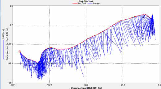
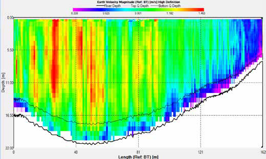
Details on the Velocity Profile: Figure 1 presents the “stick ship track plot,” which maps out the depth- averaged velocities and the positions determined by bottom tracking for the initial cross-river transect. This transect commenced from the river’s eastern side (referred to as the Left Bank when facing downstream) and concluded on the western side, marked with a red box in Figure 1. A standard vector representing a velocity of 1 m/sec is shown on the figure’s left margin for reference. Notably, the ADCP’s ability to calculate discharge is not affected by the vessel’s heading, which varied as the ferry navigated around river traffic. Figure 5 then il-lustrates the river’s cross-sectional area along with vari-ations in current speed from the surface to the riverbed. The perspective is akin to looking downstream, with the left bank at the axis’s zero point. The left bank’s side, or the eastern bank, has a greater depth of 16.4 meters and faster current speeds, peaking over 1.4 m/s, compared to the western or right bank, which has a shallower depth of at least 7.5 meters and slower speeds, less than 0.5 m/s. This differential is further highlighted by the river’s pulsing and the formation of eddies, with velocity fluctu-ations exceeding 0.5 m/s observed as the survey crossed the river’s dynamic areas.
The RiverRay ADCP proved to be a robust tool for rapid and accurate discharge measurement, even under the challenging conditions of a flooding river with a high sediment load. Four separate discharge transects were completed in under 21 minutes of sampling, yielding a mean discharge of 2,730 m³/sec with a remarkably low standard deviation. The success of the ADCP during the Teledyne Marine Technology Workshop confirmed its reliability. It showcased its potential as an essential instrument for hydrological studies and flood manage-ment in dynamic river environments.

Figure 1: Stick Ship Track Plot—1 m/sec unit vector length.

Figure 2: Velocity variation from near surface to near bottom along the transect.
